Port of rotterdam

Double your inspections with remote monitoring

Automate daily inspections for more efficient operations

Autonomous drone remote monitoring and asset inspection

Autonomous drone remote monitoring and asset inspection

Avy carries out aerial drone surveys for raw material quantity assessment at port and terminal facilities. Using thermal and RGB payloads, Aera captures precise imagery of stockpiles and storage infrastructure, allowing stakeholders to verify volumes, identify discrepancies, and reduce reliance on manual checks in hazardous or restricted areas.

Surveys can be conducted on a scheduled basis; weekly, fortnightly, or on-demand, generating consistent data sets that improve accuracy over time and integrate directly into client reporting workflows.

What remote monitoring with Avy covers

What remote monitoring with Avy covers

Power line and energy infrastructure inspection

Power line and energy infrastructure inspection

Avy conducts autonomous drone surveys for power line inspection, covering line condition assessment, rust damage, water logged foundations, resistance hot spots, fault and anomaly detection, and vegetation encroachment monitoring. Operating BVLOS, the Avy Aera can cover long linear infrastructure efficiently, surveying distances in a single flight that would take ground teams days to cover on foot.

Avy has carried out power line inspection programmes for a major European grid operator, using thermal and RGB payloads to identify structural anomalies, assess line condition, and flag vegetation risks along transmission corridors. The resulting data is delivered as structured reports with annotated imagery, ready for maintenance planning teams.

Port and terminal monitoring

Port and terminal monitoring

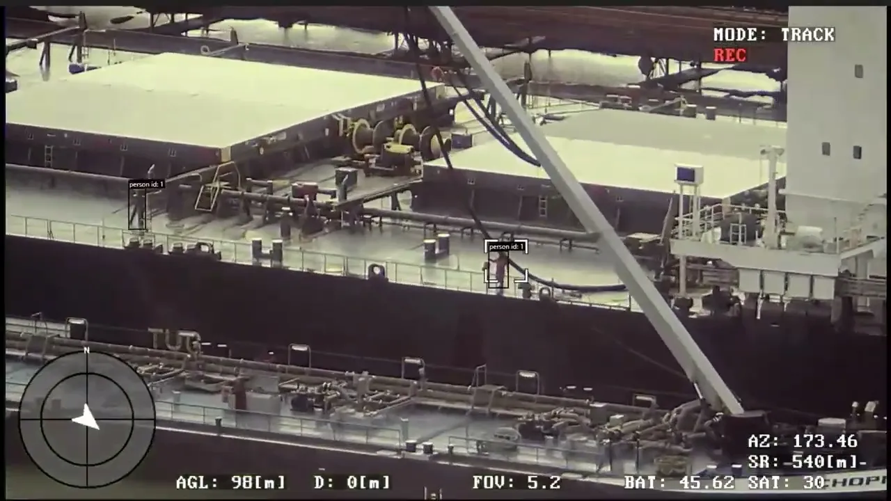
Avy operates weekly drone missions across the Port of Rotterdam, Port of Amsterdam, and Port of Antwerp for port monitoring and drone survey applications. Missions include aerial surveys of storage infrastructure, stockpile assessment, and operational monitoring of terminal activity.

The drone-in-a-box system deployed at port facilities enables recurring missions without mobilisation costs, the aircraft launches from its docking station, completes the mission autonomously, and returns to recharge.

Organisations flying with Avy

Drone being set uo

Must Read

The Port of Rotterdam

In 2021, Avy started their collaboration with the Port of Rotterdam. The goal? To support the Port Authority’s aim to make the port safer, smarter and faster with long-range drones.

Dominik Kondziela

Dominik Kondziela

Marketing & Communications Lead

Remote monitoring

Must Read

The Port of Rotterdam

In 2021, Avy started their collaboration with the Port of Rotterdam. The goal? To support the Port Authority’s aim to make the port safer, smarter and faster with long-range drones.

Dominik Kondziela

Dominik Kondziela

Marketing & Communications Lead

Rail and infrastructure hazard detection

Rail and infrastructure hazard detection

Avy has demonstrated autonomous hazard detection across rail infrastructure in a programme conducted with ProRail, the Dutch national rail operator. Drone flights identified safety-critical anomalies including incorrectly positioned vehicles and faulty fire safety equipment, hazards that are difficult to detect consistently through ground inspection across the scale of a national rail network.

The system's ability to fly consistent, repeatable routes and compare imagery against a known baseline makes it well suited to scheduled compliance monitoring for rail, road, and industrial infrastructure operators.

How autonomous remote monitoring works

How autonomous remote monitoring works

How autonomous remote monitoring works

Scheduled or on-demand missions

Flights are programmed in advance and run automatically, or triggered remotely from Avy's operations centre. No pilot needs to be present at the site.

BVLOS authorisation

Avy holds a BVLOS LUC (Light UAS Operator Certificate). This is the regulatory foundation that makes long-range autonomous monitoring programmes legally viable.

Thermal, RGB and multispectral payloads

Thermal cameras detect heat anomalies in electrical infrastructure and storage facilities. RGB cameras capture high-resolution imagery for visual condition assessment. Multispectral sensors support vegetation and environmental monitoring.

Structured data output

Raw footage and imagery is processed into structured deliverables. The output is designed to integrate into existing asset management and maintenance workflows, not just be stored as raw video files.

drone camera

Why autonomous monitoring outperforms conventional inspection

Why autonomous monitoring outperforms conventional inspection

Traditional inspection methods, whether ground teams, manned aircraft, or manually piloted drones, share a common constraint: they are expensive to deploy repeatedly, difficult to scale across large areas, and dependent on human presence at the inspection site.

Autonomous drone monitoring addresses each of these directly. Once a programme is established, recurring missions run at a fraction of the cost of manual inspection. Flight paths are consistent and repeatable, meaning data sets are directly comparable over time. And because the system operates remotely, there is no requirement to coordinate on-site access for every inspection cycle.

For infrastructure operators managing assets across large geographies, whether power transmission networks, port terminals, or rail corridors, this shift from periodic manual inspection to continuous autonomous monitoring represents a meaningful operational improvement.

Ready to automate your inspection programme?

Avy works with infrastructure operators, port authorities, and energy companies across Europe to design and operate autonomous drone monitoring programmes. Contact us to discuss your requirements.

Remote monitoring FAQs

Remote monitoring FAQs

Can you provide automated patrol routes or alerts?

Yes. Avy can configure autonomous flight paths with AI-driven alerting based on predefined zones, thermal anomalies, or object detection thresholds.

How frequently can monitoring be scheduled?

Missions can run continuously, daily, weekly, or on-demand depending on operational requirements. For clients with recurring needs, scheduled programmes eliminate the overhead of manual deployment.

Do you offer post-flight data analysis or just raw footage?

Both. Avy delivers everything from raw data to fully analysed reports with AI-driven insights, georeferenced maps, and annotated findings, structured for direct integration into asset management workflows.

Can your drones operate over water and coastal environments?

Yes. Avy operates across port environments, coastlines, and maritime facilities. The Aera is built for operational conditions including wind and rain typical of coastal and offshore locations.

What payloads are available for inspection missions?

The Aera supports thermal cameras, RGB cameras, and multispectral sensors up to 3kg. Payload configuration is matched to the specific inspection requirement: thermal for energy infrastructure, RGB for visual condition assessment, multispectral for vegetation monitoring.

What is BVLOS and why does it matter for inspection?

BVLOS, or beyond visual line of sight, is the regulatory authorisation that allows drones to fly beyond the pilot's direct line of sight. Without it, drones are limited to roughly 500 metres of usable range. Avy's BVLOS LUC authorisation is what enables long-range autonomous inspection programmes across large infrastructure assets.

Can you provide automated patrol routes or alerts?

Yes. Avy can configure autonomous flight paths with AI-driven alerting based on predefined zones, thermal anomalies, or object detection thresholds.

Do you offer post-flight data analysis or just raw footage?

We offer both — from raw data to fully analyzed reports with AI-driven insights, maps, and annotated findings.

How frequently can monitoring be scheduled?

Monitoring can be scheduled on a continuous, daily, weekly, or on-demand basis, depending on your surveillance requirements.

What payloads are available for inspection missions?

The Aera supports thermal cameras, RGB cameras, and multispectral sensors up to 3kg. Payload configuration is matched to the specific inspection requirement: thermal for energy infrastructure, RGB for visual condition assessment, multispectral for vegetation monitoring.

What is BVLOS and why does it matter for inspection?

BVLOS, or beyond visual line of sight, is the regulatory authorisation that allows drones to fly beyond the pilot's direct line of sight. Without it, drones are limited to roughly 500 metres of usable range. Avy's BVLOS LUC authorisation is what enables long-range autonomous inspection programmes across large infrastructure assets.

Can you provide automated patrol routes or alerts?

Yes. Avy can configure autonomous flight paths with AI-driven alerting based on predefined zones, thermal anomalies, or object detection thresholds.

How frequently can monitoring be scheduled?

Missions can run continuously, daily, weekly, or on-demand depending on operational requirements. For clients with recurring needs, scheduled programmes eliminate the overhead of manual deployment.

Do you offer post-flight data analysis or just raw footage?

Both. Avy delivers everything from raw data to fully analysed reports with AI-driven insights, georeferenced maps, and annotated findings, structured for direct integration into asset management workflows.

Can your drones operate over water and coastal environments?

Yes. Avy operates across port environments, coastlines, and maritime facilities. The Aera is built for operational conditions including wind and rain typical of coastal and offshore locations.

What payloads are available for inspection missions?

The Aera supports thermal cameras, RGB cameras, and multispectral sensors up to 3kg. Payload configuration is matched to the specific inspection requirement: thermal for energy infrastructure, RGB for visual condition assessment, multispectral for vegetation monitoring.

What is BVLOS and why does it matter for inspection?

BVLOS, or beyond visual line of sight, is the regulatory authorisation that allows drones to fly beyond the pilot's direct line of sight. Without it, drones are limited to roughly 500 metres of usable range. Avy's BVLOS LUC authorisation is what enables long-range autonomous inspection programmes across large infrastructure assets.